We recently hit the trails to clear and mark yet another route into Longmore Forest, namely The Forts. With an abundance of history and several incredible features along the way, the newly marked Forts route provides trail users with a 41km route with approximately 1000m elevation and is clearly marked with a bright green arrow.
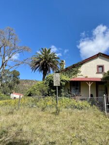
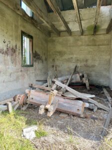
The Forts route starts by ascending Ox Wagon Pass and taking a right turn just before the climb to the Ox Wagon bench. It then continues around towards the back of Ox Wagon, past the red and black turn into Ox Wagon and towards the back of the Longmore Tower. This scenic route takes trail users past two historic forts, built during the Anglo-Boer War, the upper Van Stadens Dam, a beautiful waterfall and pool and the original Van Stadens Dam caretaker’s cottage which is home to the original Ox Wagon which was used during the Anglo-Boer War.
Background of the Anglo-Boer War
The Anglo-Boer War was fought between Britain and the Boers, which consisted of the South African Republic and the Republic of the Orange Free State. The war began on the 11th October 1899 and continued for 2 years and 8 months, ending on 31st May 1902.
Background of the Anglo-Boer War in Port Elizabeth
Although, Port Elizabeth was never occupied or fought over, precautionary measures were put in place in the unlikely event that there was a Boer raid. During the war, the British received word of a possible Boer invasion which led to the construction of a series of forts and trenches around Port Elizabeth and the surrounding areas. Volunteers being asked to man these defences.
The Upper Van Stadens Dam
One of the strategic key points in the Port Elizabeth region was the Van Stadens Dam. The dam was conceptulised in 1862 when the issue of water supply and security to Port Elizabeth was raised. The development of the Upper Van Stadens Dam with its intake weirs, filter beds and caretaker’s cottage was completed in 1893. Approximately 3 km downstream, a pump house and weir were constructed in 1899.
Protecting the Upper Van Stadens Dam
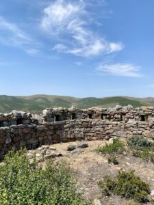
During the Boer War a battalion was created to protect the dam and surrounding infrastructure which consisted of two parties – one party to protect the pump house and the other party to protect the dam. The battalion remained at the Upper Van Stadens dam for three months and during this time constructed two small forts – a lower and upper fort which are both still visible and today and can be seen along the route.
The Upper Fort
The Upper Fort has a circular plan with an external diameter of approximately 10 metres. It has an internal wall below the loopholes and an external slope to the wall. The entrance on the south side is covered by a loop-holed screen wall and a paved walkway runs around the inside of the circular wall.
The Lower Fort
The Lower Fort is in the shape of a parallelogram with rounded ends. The walls are 700 mm thick and have an external slope. In the middle of the east wall, is the entrance which is protected by a projecting right-angled wall. Outside the entrance, a 1m wide and 1.2 m deep trench begins and extends 22 metres east down the hill and joins a U-shaped trench. This was built as a hidden access to the fort as this slope faces directly onto the Upper Dam and the caretaker’s cottage.
A huge thanks goes to our 3Rivers local trail legend, Mark Ackerman, for scouting the route and assisting with the marking. We truly appreciate the help and support.